- New license application for the Mulla gold copper porphyry project, covering 616km2 to the south of ongoing drilling at the Nyngan project and adjacent to the Nevertire project
- The Mulla project covers a regionally significant, multiple phase intrusive complex as indicated by an extensive gravity low and some minimal past drilling. Past hydro-geochemical sampling of water bores identified two relatively shallowly covered target zones
- The 100%-owned Nyngan, Nevertire and Mulla gold copper projects cover an area of approximately 1,761km2 in a highly prospective geologic terrane with encouraging limited previous explorer drilling and increasing neighboring ground pegging and drilling activities
- Kincora’s drilling programs continue at the Trundle and the Nyngan projects, with preparations advanced to commence drilling next month at the Fairholme project and as Sultan Resources’ continues drilling within 300 metres of our Cundumbul project
MELBOURNE, Australia, June 9, 2021 /CNW/ – Kincora Copper Ltd. (the “Company”, “Kincora”) (ASX: KCC) (TSXV: KCC) is pleased to have applied directly to the NSW State Government for a new exploration license (ELA6304), the Mulla gold copper porphyry project (“Mulla”). The Mulla project covers 616km2 and is located in the interpreted northern undercover and underexplored section of the Junee-Narromine Belt of the Macquarie Arc of the Lachlan Fold Belt in NSW, Australia, and south of the Company’s ongoing drilling at the Nyngan project.
John Holliday, Technical Committee chair, and Peter Leaman, Senior VP of Exploration, commented: “The Mulla project covers a regionally significant gravity low feature which we consider, based on prior limited drilling and regional geophysics, could potentially host a porphyry complex within Macquarie Arc rocks under relatively shallow cover.
Similar large-scale gravity lows in the Junee-Narromine Belt of the Macquarie Arc are associated with the world-class Cowal and Northparkes mineralised systems, and the Myall porphyry exploration project”.
Sam Spring, President & CEO, stated: “The Mulla project hasn’t been drill tested since pre Bre-X, with two broad target zones already identified for follow up activities.
Mulla adds to the Company’s project pipeline in Australia’s leading porphyry belt at a time of increasing neighbouring ground pegging and drilling activities. Only in the last few weeks we have seen significant land grabs in the belt from majors and juniors alike, including adjacent to ongoing drilling activities at our Trundle and Nyngan projects”.
Mulla project background
The last period of exploration undertaken within the license area was by Burdekin Resources NL (“Burdekin”) before the Bre-X downturn. Burdekin followed up then new regional airborne geophysical data and the “Discovery 2000” water bore hydro-geochemical sampling program, both undertaken by the NSW Department of Mineral Resources.
The Mulla project is situated on a large regionally significant gravity low. A number of significant porphyry related systems and world-class mining operations sit on similar regionally significant gravity lows and major intrusive complexes within the Junee-Narromine Belt of the Macquarie Arc – Figure 2.
Figure 1: Recent significant pegging activities, key projects and Kincora’s pipeline of near term drill project
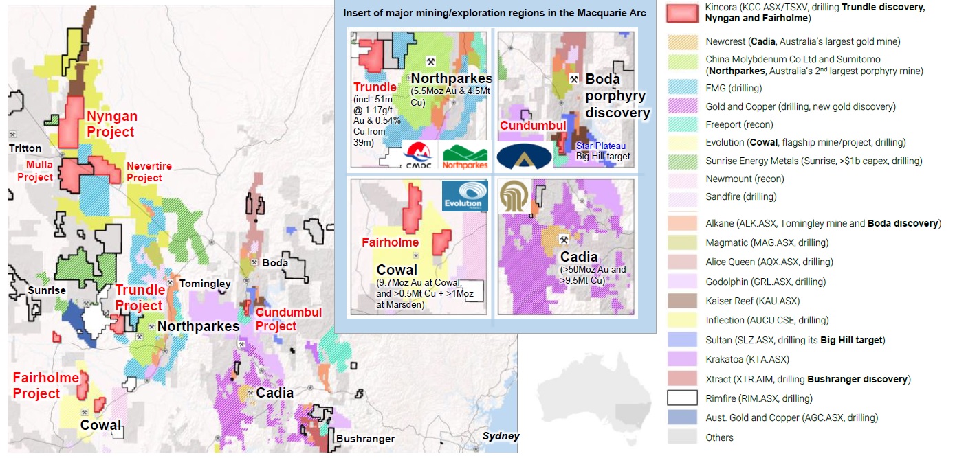
- Key Lachlan Fold Belt players/junior explorers, including pegging since Mar’21 with shadow outlines
- Kincora is currently drilling at the Trundle and Nyngan projects, preparing for drilling at the Fairholme project, and Sultan Resources is currently drilling within 300 metres of the license boundary testing a common target at the Cundumbul project
- Central West, New South Wales, Australia
The public access aeromagnetic and gravity data indicates the existence of several large intrusive volcanic complexes, some of which have been confirmed as multiple-phase diorite-monzonite-quartz monzonite intrusions via Burdekin’s limited and shallow drilling of 8 holes for 917 metres – see Figure 3.
Little prior modern exploration has been undertaken on the license area because prospective basement rocks are masked by post-mineral cover. Limited drilling (depth of holes referenced in Figure 3) has proven the cover to be shallow with Artificial Intelligence using Self Organizing Maps (“SoM”) adopting neural networks of airborne geophysics coupled with prior end of hole lithology assisting Kincora’s direct application selection.
Figure 2: The Mulla project sits on a regionally significant intrusive complex
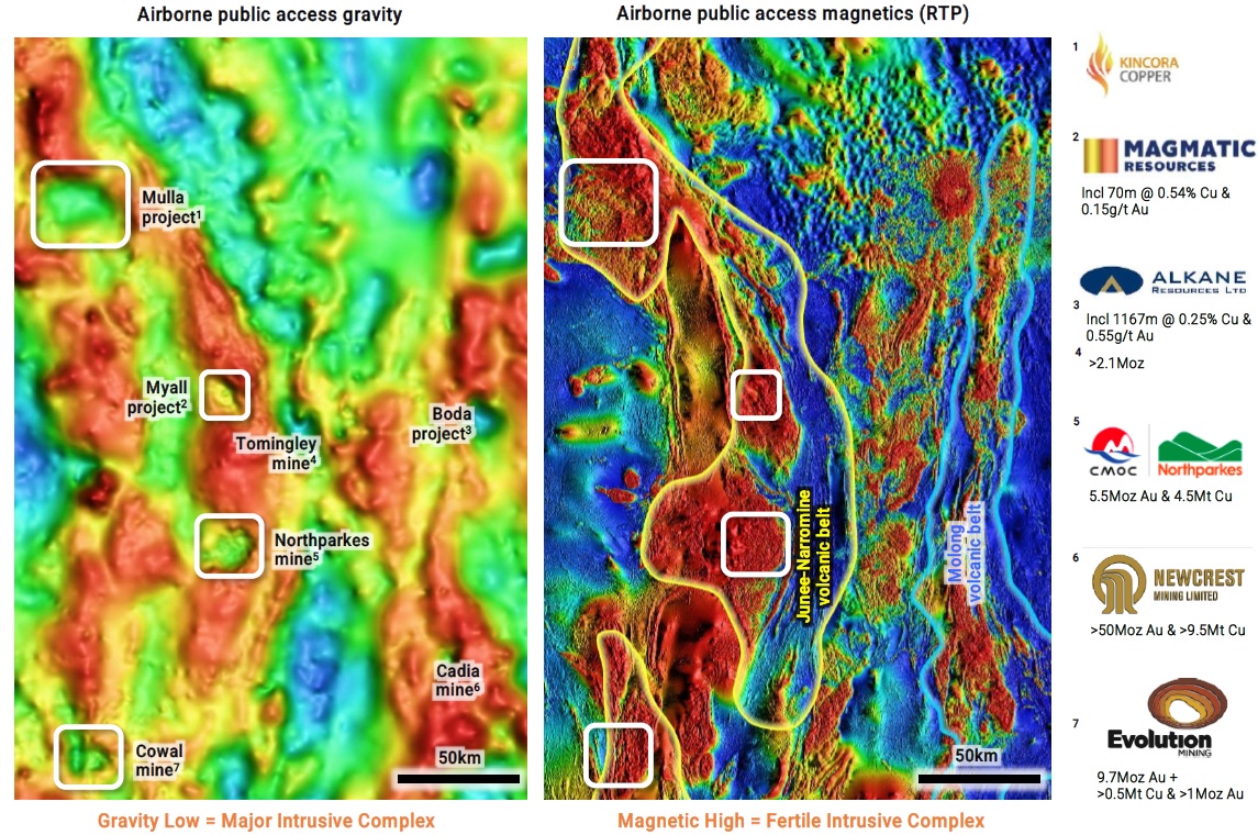
A number of key porphyry deposits and world-class mining operations sit on regionally significant gravity lows, potentially indicative of major intrusive complexes, within the Junee-Narromine Belt of the Macquarie Arc
Two broad hydro-geochemical target areas were identified by Burdekin with anomalous gold and molybdenum values, and remain untested on complementary gravity and magnetic anomalies. Of note, these values at the Adavale-Mullengudgery zone are in-line or exceed ground waters around the open pits at the Northparkes mine1, and, at the other Mulla target, the Yamba-Mia Mia zone, prior hydro-geochemical and down hole results indicate the potential presence of a fractionated I-type pluton which may have undergone potassic alteration1.
Kincora is pleased to have made direct applications to the NSW government for the Nyngan, Nevertire and Mulla gold copper projects, which cover an area of approximately 1,761km2 in a highly prospective geologic terrane with encouraging limited previous explorer drilling and increasing neighbouring ground pegging and drilling activities. Recent pegging activities in the belt illustrated in Figure 1, including adjacent to Kincora’s Trundle and Nyngan projects.
The Company’s drilling programs continue at the Trundle (Trundle Park target) and the Nyngan (hole one of a two hole program) projects. Kincora will provide exploration updates in due course and it is noted Sultan Resources maiden diamond drilling campaign at the Big Hill target “continues to progress well” (reference Sultan Resources June 3rd, 2021 press release) within 300 metres of the license boundary of Kincora’s Cundumbul project (for further details refer to Kincora’s May 19th, 2021 press release).
Figure 3: Artificial Intelligence using Self Organizing Maps of airborne geophysics coupled with prior end of hole lithology assisted Kincora’s direct application selection
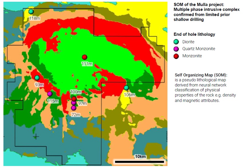
Two mineralised target zones remain untested having been identified by prior explorer activities that ceased due to the Bre-X downturn
Figure 4: The Mulla project is south of ongoing Kincora, and Inflections’ recent, drilling activities and is adjacent to two FMG licenses and Kincora’s Nevertire project
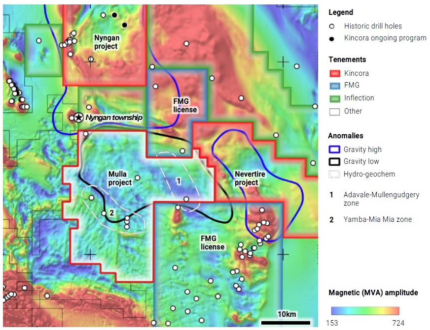
The northern Junee-Narromine belt potentially covers the largest intrusive centre of the Macquarie Arc and with a jog and structural grain parallel to the Lachlan Transverse Zone, possibly indicating a locus for porphyry formation
|
1 Sourced: Public access file – 1997 annual report from Burdekin Resources NL for EL4996 Nyngan
|
This announcement has been authorised for release by the Board of Kincora Copper Limited (ARBN 645 457 763)
Forward-Looking Statements
Certain information regarding Kincora contained herein may constitute forward-looking statements within the meaning of applicable securities laws. Forward-looking statements may include estimates, plans, expectations, opinions, forecasts, projections, guidance or other statements that are not statements of fact. Although Kincora believes that the expectations reflected in such forward-looking statements are reasonable, it can give no assurance that such expectations will prove to have been correct. Kincora cautions that actual performance will be affected by a number of factors, most of which are beyond its control, and that future events and results may vary substantially from what Kincora currently foresees. Factors that could cause actual results to differ materially from those in forward-looking statements include market prices, exploitation and exploration results, continued availability of capital and financing and general economic, market or business conditions. The forward-looking statements are expressly qualified in their entirety by this cautionary statement. The information contained herein is stated as of the current date and is subject to change after that date. Kincora does not assume the obligation to revise or update these forward-looking statements, except as may be required under applicable securities laws.
Neither the TSX Venture Exchange nor its Regulation Services Provider (as that term is defined in the policies of the TSX Venture Exchange) or the Australian Securities Exchange accepts responsibility for the adequacy or accuracy of this release.
Qualified Person
The scientific and technical information in this news release was prepared in accordance with the standards of the Canadian Institute of Mining, Metallurgy and Petroleum and National Instrument 43-101 – Standards of Disclosure for Mineral Projects (“NI 43-101”) and was reviewed, verified and compiled by Kincora’s geological staff under the supervision of Paul Cromie (BSc Hons. M.Sc. Economic Geology, PhD, member of the Australian Institute of Mining and Metallurgy and Society of Economic Geologists), Exploration Manager Australia, who is the Qualified Persons for the purpose of NI 43-101.
JORC Competent Person Statement
Information in this report that relates to Exploration Results, Mineral Resources or Ore Reserves has been reviewed and approved by Paul Cromie, a Qualified Person under the definition established by JORC and have sufficient experience which is relevant to the style of mineralization and type of deposit under consideration and to the activity being undertaking to qualify as a Competent Person as defined in the 2012 Edition of the ‘Australasian Code for Reporting of Exploration Results, Mineral Resources and Ore Reserves’.
Paul Cromie (BSc Hons. M.Sc. Economic Geology, PhD, member of the Australian Institute of Mining and Metallurgy and Society of Economic Geologists), is Exploration Manager Australia for the Company. Paul Cromie consents to the inclusion in this report of the matters based on his information in the form and context in which it appears.
The review and verification process for the information disclosed herein for the Nyngan project has included the receipt of all material exploration data, results and sampling procedures of previous operators and review of such information by Kincora’s geological staff using standard verification procedures.
JORC TABLE 1
Section 1 Sampling Techniques and Data
(Criteria in this section apply to all succeeding sections).
|
Criteria
|
JORC Code explanation
|
Commentary
|
|
Sampling techniques
|
- Nature and quality of sampling (e.g. cut channels, random chips, or specific specialised industry standard measurement tools appropriate to the minerals under investigation, such as down hole gamma sondes, or handheld XRF instruments, etc.). These examples should not be taken as limiting the broad meaning of sampling.
- Include reference to measures taken to ensure sample representivity and the appropriate calibration of any measurement tools or systems used.
- Aspects of the determination of mineralisation that are Material to the Public Report.
- In cases where ‘industry standard’ work has been done this would be relatively simple (e.g. ‘reverse circulation drilling was used to obtain 1 m samples from which 3 kg was pulverised to produce a 30 g charge for fire assay’). In other cases more explanation may be required, such as where there is coarse gold that has inherent sampling problems. Unusual commodities or mineralisation types (e.g., submarine nodules) may warrant disclosure of detailed information
|
- Kincora Copper Limited is the operator of the Mulla Project, having applied directly to the NSW State Government for a new exploration license (ELA6304), and has reviewed previous public file historical exploration activities and results.
- Previous air core and mud-rotary drilling with diamond core tails was conducted in Mulla project area by BHP and Burdekin Resources NL.
- Groundwater from existing bores were sampled and analysed for a wide range of elements with two programs of note, the “Discovery 2000” water bore hydro-geochemical sampling program by the then NSW Department of Mineral Resources which was followed up by Burdekin Resources NL.
- One or two metre composite samples were taken from the RAB and Diamond drilling.
- Regional airborne geophysical data is publically available over the project area.
- Previous public file data and results are available from MinView (minview.geoscience.nsw.gov.au) and DIGS.
|
|
Drilling techniques
|
- Drill type (e.g. core, reverse circulation, open-hole hammer, rotary air blast, auger, Bangka, sonic, etc) and details (e.g. core diameter, triple or standard tube, depth of diamond tails, face-sampling bit or other type, whether core is oriented and if so, by what method, etc.).
|
- Historic drilling on Kincora projects used a variety of methods including air core, mud-rotary, and diamond core.
- The last drilling program at the Mulla project commenced in September 1996. The drilling Contractor was Anderson Drilling of Orange, NSW. The rig employed was a new UDR-650 multi-purpose rig, fitted with a Sullair 900cfm x 350 psi air compressor. Drilling method used was aircore, using 4.5-inch rods and both clay and coring bits. Drilling was done dry, or with water injection as and when required. Later holes were drilled using an Edson 3000 aircore rig, with NQ diamond tails drilled using an Investigator Mk V rig.
|
|
Drill sample recovery
|
- Method of recording and assessing core and chip sample recoveries and results assessed.
- Measures taken to maximise sample recovery and ensure representative nature of the samples.
- Whether a relationship exists between sample recovery and grade and whether sample bias may have occurred due to preferential loss/gain of fine/coarse material.
|
- Drill Core recovery was logged in diamond drilling tails only in historical drilling.
- Core recovery ranged between 42-100%.
|
|
Logging
|
- Whether core and chip samples have been geologically and geotechnically logged to a level of detail to support appropriate Mineral Resource estimation, mining studies and metallurgical studies.
- Whether logging is qualitative or quantitative in nature. Core (or costean, channel, etc.) photography.
- The total length and percentage of the relevant intersections logged.
|
Drilling program:
- All historical Aircore, RAB and diamond holes are geologically logged for their entire length including lithology, sample color, alteration and mineralisation.
|
|
Sub-sampling techniques and sample preparation
|
- If core, whether cut or sawn and whether quarter, half or all core taken.
- If non-core, whether riffled, tube sampled, rotary split, etc. and whether sampled wet or dry.
- For all sample types, the nature, quality and appropriateness of the sample preparation technique.
- Quality control procedures adopted for all sub-sampling stages to maximise representivity of samples.
- Measures taken to ensure that the sampling is representative of the in situ material collected, including for instance results for field duplicate/second-half sampling.
- Whether sample sizes are appropriate to the grain size of the material being sampled.
|
Ground water analysis program:
- Water bore samples were collected by two means: (1) where windmills, or electric pumps were fitted to bores, freshly pumped samples were collected directly from the outlet pipe, and (2) where open bores were to be sampled, a special bailer was lowered down the bore by hand, and a water sample collected 5 metres below the standing water level.
- Waters were collected in 2 x 1 litre polythene bottles, and 1x 0.5 litre polythene bottle.
Drilling program:
- For drill holes, samples were airlifted to the surface by compressed air, whilst the rod string was at the bottom of the hole. This gave rise to a very muddy sample, but for most samples, settling of the clays took place in 15 to 20 minutes, allowing a clear sample to be decanted into sample bottles. Some changes in the chemical properties of the waters may have occurred during this process. When samples could not be collected immediately after completion of drilling, the holes were sampled using the special bailer.
- No duplicate samples were taken.
|
|
Quality of assay data and laboratory tests
|
- The nature, quality and appropriateness of the assaying and laboratory procedures used and whether the technique is considered partial or total.
- For geophysical tools, spectrometers, handheld XRF instruments, etc, the parameters used in determining the analysis including instrument make and model, reading times, calibrations factors applied and their derivation, etc.
- Nature of quality control procedures adopted (e.g. standards, blanks, duplicates, external laboratory checks) and whether acceptable levels of accuracy (ie lack of bias) and precision have been established.
|
Ground water chemistry program:
- All drill holes waters were sampled, and dispatched to the CSIRO Mineral Development Laboratories in North Ryde for chemical analysis.
- The carbon is ultimately analysed by INNA methods, and the gold content of the water sample can be very accurately determined.
- Sample were used for analysis of about 52 elements by ICP-OES and/or ICP-MS at CSIRO Mineral Development Laboratories in North Ryde for analysis.
Bedrock chemistry program:
- Drill holes that intersected basement rocks were sampled for chemical analysis. In all cases, a short interval of cover rocks sitting immediately above basement was also sampled. Samples were dispatched to ALS laboratories in Orange for analysis. Elements measured were Au, Cu, Pb, Zn, Ag, As, Fe, Bi, Ca, Mg, Mo, Ni and Sb, using method PM-205 for Au and IC-205 for all other elements.
|
|
Verification of sampling and assaying
|
- The verification of significant intersections by either independent or alternative company personnel.
- The use of twinned holes.
- Documentation of primary data, data entry procedures, data verification, data storage (physical and electronic) protocols.
- Discuss any adjustment to assay data.
|
- All data are verified during the exploration programs.
- No twinned holes have been completed.
- The intercepts have not been verified by independent personal.
- Logging data is captured manually and stored in a hardcopy.
|
|
Location of data points
|
- Accuracy and quality of surveys used to locate drill holes (collar and down-hole surveys), trenches, mine workings and other locations used in Mineral Resource estimation.
- Specification of the grid system used.
- Quality and adequacy of topographic control.
|
- A handheld GPS was used to locate each sample point. Accuracy of +/- 5m is considered reasonable.
- Collar positions are set up using a hand-held GPS.
- Grid system used is the Australian Map Grid Zone 55, AGD 66 datum.
|
|
Data spacing and distribution
|
- Data spacing for reporting of Exploration Results.
- Whether the data spacing and distribution is sufficient to establish the degree of geological and grade continuity appropriate for the Mineral Resource and Ore Reserve estimation procedure(s) and classifications applied.
- Whether sample compositing has been applied.
|
- Other historic drilling on Mulla project was completed at various drill hole spacings and no other projects have spacing sufficient to establish a mineral resource.
|
|
Orientation of data in relation to geological structure
|
- Whether the orientation of sampling achieves unbiased sampling of possible structures and the extent to which this is known, considering the deposit type.
- If the relationship between the drilling orientation and the orientation of key mineralised structures is considered to have introduced a sampling bias, this should be assessed and reported if material.
|
- No orientation data was collected during the historical drilling programs.
|
|
Sample security
|
- The measures taken to ensure sample security.
|
- All samples were selected by geologists in the field and then delivered directly to the laboratory.
|
|
Audits or reviews
|
- The results of any audits or reviews of sampling techniques and data.
|
No audits were conducted on the historical datasets.
|
Section 2 Reporting of Exploration Results
(Criteria listed in the preceding section also apply to this section.)
|
Criteria
|
JORC Code explanation
|
Commentary
|
|
Mineral tenement and land tenure status
|
- Type, reference name/number, location and ownership including agreements or material issues with third parties such as joint ventures, partnerships, overriding royalties, native title interests, historical sites, wilderness or national park and environmental settings.
- The security of the tenure held at the time of reporting along with any known impediments to obtaining a licence to operate in the area.
|
- Kincora holds two granted exploration licenses and one exploration license application in NSW, and rights to a further six exploration licenses through an agreement with RareX Limited (RareX).
- EL8222, EL6552, EL6915, EL8960, EL6661 and EL7748 are in a JV with RareX where Kincora has a 65% interest in the respective 6 licenses and is the operator /sole funder of all further exploration until a positive scoping study or preliminary economic assessment (“PEA”) on a project by project basis. Upon completion of PEA, a joint venture will be formed with standard funding/dilution and right of first refusal on transfers.
- EL8502 and EL8929 are granted exploration licenses wholly owned by Kincora.
- ELA6304 is an exploration license application wholly owned by Kincora.
- All licenses are in good standing and there are no known impediments to obtaining a Licence to operate.
|
|
Exploration done by other parties
|
- Acknowledgment and appraisal of exploration by other parties.
|
- All Kincora projects have had previous exploration work undertaken.
The review and verification process for the information disclosed herein and of other parties for the Mulla Project has included the receipt of all publically available open file material exploration data, results and sampling procedures of previous operators and review of such information by Kincora’s geological staff using standard verification procedures.
Further details of exploration efforts and data of other parties for licenses EL8222, EL6552, EL6915, EL8960, EL6661, EL7748, EL8502 and EL8929 are provided in the March 1st, 2021, Independent Technical Report included in the Company’s ASX listing prospectus, which is available at:
- https://www.kincoracopper.com/investors/asx-prospectus
|
|
Geology
|
- Deposit type, geological setting and style of mineralisation.
|
- The Nyngan (and Walgett) 1:250,000 map sheet areas cover the Mulla Project (ELA630) and are situated predominantly in the Coonamble Embayment, which is the shallow, southern continuation of the Surat Basin. Palaeozoic rocks of the Lachlan fold belt form the basement to the Coonamble Embayment. These Palaeozoic rocks comprise parts of five structural zones (interpreted from geophysical data) which contain distinctive geology and tectonic style (Schiebner & Basden 1996). The Mulla project lies wholly within the Girilambone Zone of Schiebner & Basden (1996) and comprises multiply deformed metasediments and greenstones (ultramafic) of Cambro-Ordovician age. The Nyngan Igneous complex has been intruded into this substrate in mid Silurian times, and its orientation and emplacement may have been controlled by the “Nyngan Transverse Zone” of Hilyard et al. (1996). This zone parallels the Lachlan River Lineament of Scheibner and Stevens (1974) some 120 kms to the south. This latter lineament is considered to be a fundamental structure, and it is possible that the Nyngan Transverse Zone has a similar character.
|
|
Drill hole Information
|
- A summary of all information material to the understanding of the exploration results including a tabulation of the following information for all Material drill holes:
- easting and northing of the drill hole collar
- elevation or RL (Reduced Level – elevation above sea level in metres) of the drill hole collar
- dip and azimuth of the hole
- down hole length and interception depth
- hole length.
- If the exclusion of this information is justified on the basis that the information is not Material and this exclusion does not detract from the understanding of the report, the Competent Person should clearly explain why this is the case.
|
- Detailed information on historic drilling at the Mulla project is given in the body of the report.
|
|
Data aggregation methods
|
- In reporting Exploration Results, weighting averaging techniques, maximum and/or minimum grade truncations (e.g. cutting of high grades) and cut-off grades are usually Material and should be stated.
- Where aggregate intercepts incorporate short lengths of high-grade results and longer lengths of low-grade results, the procedure used for such aggregation should be stated and some typical examples of such aggregations should be shown in detail.
- The assumptions used for any reporting of metal equivalent values should be clearly stated.
|
|
|
Relationship between mineralisation widths and intercept lengths
|
- These relationships are particularly important in the reporting of Exploration Results.
- If the geometry of the mineralisation with respect to the drill hole angle is known, its nature should be reported.
- If it is not known and only the down hole lengths are reported, there should be a clear statement to this effect (e.g., ‘down hole length, true width not known’).
|
- Due to the uncertainty of mineralisation orientation, the true width of mineralisation is not known at the Mulla project.
- Intercepts from historic drilling reported at other projects are also of unknown true width.
|
|
Diagrams
|
- Appropriate maps and sections (with scales) and tabulations of intercepts should be included for any significant discovery being reported These should include, but not be limited to a plan view of drill hole collar locations and appropriate sectional views.
|
- Relevant diagrams are included in the body of the report.
|
|
Balanced reporting
|
- Where comprehensive reporting of all Exploration Results is not practicable, representative reporting of both low and high grades and/or widths should be practiced to avoid misleading reporting of Exploration Results.
|
- Intercepts reported for historic drilling at the Mulla project are zones of anomalous results as reported by previous explorers within unmineralized or weakly anomalous material.
|
|
Other substantive exploration data
|
- Other exploration data, if meaningful and material, should be reported including (but not limited to): geological observations; geophysical survey results; geochemical survey results; bulk samples – size and method of treatment; metallurgical test results; bulk density, groundwater, geotechnical and rock characteristics; potential deleterious or contaminating substances.
|
- No other exploration data is considered material to the reporting of results at Mulla. Other data of interest to further exploration targeting is included in the body of the report.
- Historic exploration data coverage and results are included in the body of the report for Kincora’s other projects.
|
|
Further work
|
- The nature and scale of planned further work (e.g. tests for lateral extensions or depth extensions or large-scale step-out drilling).
- Diagrams clearly highlighting the areas of possible extensions, including the main geological interpretations and future drilling areas, provided this information is not commercially sensitive.
|
- Further exploration and drilling is proposed to follow up previous results at the Mulla project and the Company plans to drill other project areas that have complementary but insufficiently tested geochemistry and geophysical targets with the aim to find: (a) and expand near surface copper-gold skarn mineralization overlying or adjacent to (b) underlying copper-gold porphyry systems.
|


